
Before you take your first step toward Choquequirao Archaeological Complex, it helps to understand the trail ahead.
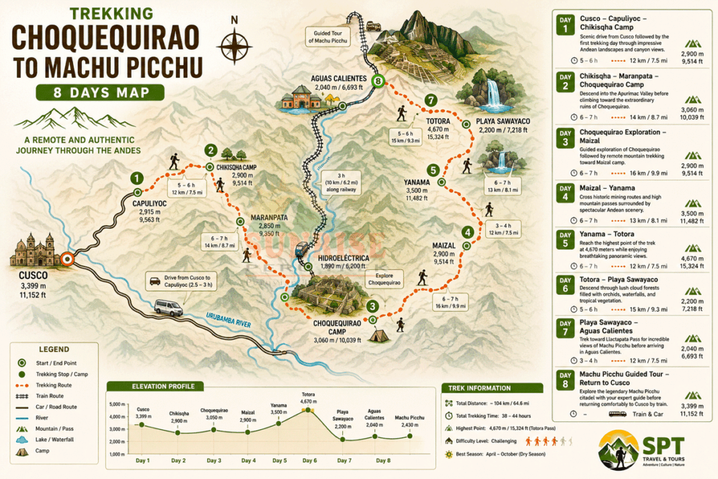
The Choquequirao Trek Map reveals more than a line through the Andes. It shows a demanding journey from the highlands down into the Apurímac Canyon, across the river, and back up toward one of Peru’s most remarkable Inca archaeological sites. Understanding the route, elevation changes, and main stops will help you prepare—and build excitement for the adventure.
Where Is the Choquequirao Trek?
Choquequirao is located in the Vilcabamba mountain region of the Cusco area, on the slopes above the Apurímac River canyon. Peru’s official tourism information places the archaeological complex at approximately 3,033–3,050 meters (9,950–10,000 ft) above sea level.
The classic trekking approach begins after traveling from Cusco toward Capuliyoc, near Cachora. From there, the trail descends dramatically toward the Apurímac River before climbing through Santa Rosa and Marampata to Choquequirao.
The exact route and distances can vary depending on the itinerary and starting point.
Choquequirao Trek Route at a Glance
For the current Choquequirao.biz 4-day route, the journey follows this general sequence:
Cusco → Capuliyoc → Chikisca → Playa Rosalina → Santa Rosa → Marampata → Choquequirao → Marampata → Santa Rosa → Chikisca → Capuliyoc → Cusco
The current itinerary describes Capuliyoc as the trailhead, followed by a descent into the canyon, the crossing of the Apurímac River, and a major ascent toward Marampata and Choquequirao.
Key Points on the Choquequirao Trek Map
- Capuliyoc: The main starting point for the trek, with spectacular views over the Apurímac Canyon.
- Chikisca: A lower canyon settlement and important stopping point on the route.
- Playa Rosalina: Located beside the Apurímac River and reached after a significant descent.
- Apurímac River: One of the most dramatic geographical features of the trek. Crossing the river marks the transition from the canyon floor toward the long ascent.
- Santa Rosa: A key rest and camping area before the climb toward Marampata.
- Marampata: A mountain settlement where trekkers can rest and enjoy views toward Choquequirao.
- Choquequirao Archaeological Site: The destination of the trek, situated at roughly 3,050 m and surrounded by the spectacular Vilcabamba landscape.
Choquequirao Trek Distance & Elevation
There is no single distance that applies to every Choquequirao hiking route. Operators use different itineraries, starting points, camping locations, and return options.
For the current Choquequirao.biz Standard 4-Day itinerary:
| Route section | Verified information |
|---|---|
| Capuliyoc → Chikisca → Playa Rosalina → Santa Rosa | Approx. 15 km, 6–7 hours |
| Santa Rosa → Marampata → Choquequirao → Marampata | 7–8 hours, maximum elevation about 3,050 m |
| Marampata → Santa Rosa → Chikisca | 5–6 hours |
| Chikisca → Capuliyoc | Approx. 8 km, 3–4 hours |
The overall route ranges from approximately 1,550 m in the lower canyon to around 3,050 m at Choquequirao, creating substantial elevation changes over several days.
How Difficult Is the Choquequirao Trek?
The Choquequirao Trek is moderate to challenging, depending on the itinerary and your fitness level. Expect steep descents, long uphill sections, rocky mountain trails, warm conditions in the canyon, and cooler temperatures at higher elevations.
Good preparation matters. Spend at least a couple of days acclimatizing in Cusco, wear well-broken-in hiking shoes, carry enough water, use sun protection, and pace yourself on the steep climbs.
The challenge is part of the reward: every difficult ascent brings you closer to an extraordinary archaeological discovery.
Can You Trek Choquequirao Without a Guide?
Independent trekking may be possible depending on the route and current access conditions, but an organized Choquequirao Trek guide can make a major difference.
A local trekking team can assist with route navigation, meals, accommodation or camping logistics, pack-horse support where included, transportation, first-aid preparedness, and interpretation of the archaeological site. The current Choquequirao.biz itinerary includes a professional bilingual guide and organized trekking support.
Why Is the Choquequirao Trek Worth It?
The map shows the route—but it cannot show how it feels to finally stand at Choquequirao.
You walk from the high Andes into the immense Apurímac Canyon, experience dramatic changes in landscape and climate, and eventually reach an extraordinary Inca sanctuary far from the busiest tourist trails.
It is not simply a way to reach an archaeological site. The journey itself is part of the discovery.
If you’re planning a Choquequirao Trek Peru adventure, explore the itinerary, prepare for the elevation changes, and choose the route that matches your experience and fitness.
Study the map. Prepare your boots. Then follow the trail into the Andes.
Explore the Choquequirao Trek itinerary and plan your adventure with Choquequirao.biz.